Documentation Revision Date: 2025-04-03
Dataset Version: 1
Summary
There are two data files in cloud optimized GeoTIFF format.
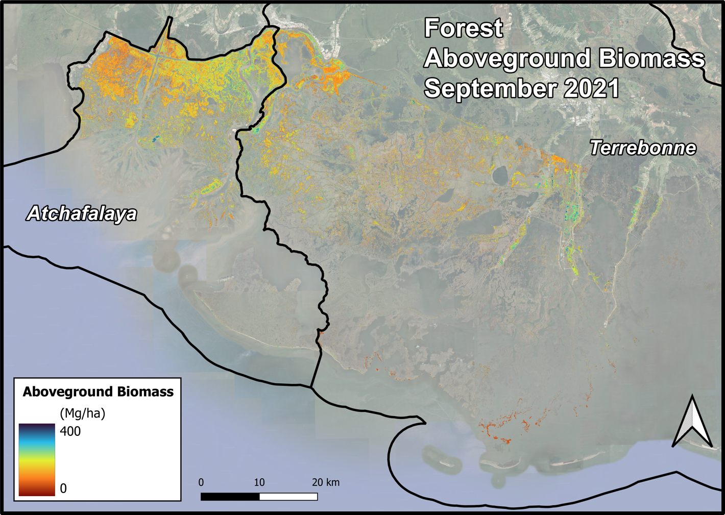
Figure 1. Forest aboveground biomass (megagrams/hectare) product for the Atchafalaya and Terrebonne Basins derived from AVIRIS-NG and UAVSAR data collected during the September 2021 deployment.
Citation
Jensen, D.J., E. Castañeda-Moya, E. Solohin, M.W. Denbina, D.R. Thompson, and M. Simard. 2025. Delta-X AVIRIS-NG and UAVSAR L3 Derived Forest Aboveground Biomass, MRD, LA. ORNL DAAC, Oak Ridge, Tennessee, USA. https://doi.org/10.3334/ORNLDAAC/2410
Table of Contents
- Dataset Overview
- Data Characteristics
- Application and Derivation
- Quality Assessment
- Data Acquisition, Materials, and Methods
- Data Access
- References
Dataset Overview
This dataset contains estimates of forest aboveground biomass (AGB) across the Atchafalaya and Terrebonne Basins, Louisiana, US. During Spring and Fall 2021, NASA’s Next Generation Airborne Visible Infrared Imaging Spectrometer (AVIRIS-NG) and Uninhabited Aerial Vehicle Synthetic Aperture Radar (UAVSAR) acquired data over regions of interest in the Atchafalaya and Terrebonne basins. AGB was derived from AVIRIS-NG surface reflectance and UAVSAR products. L2B BRDF-adjusted surface reflectance (Thompson et al., 2023) was produced after applying atmospheric correction to L2 Hemispherical-Directional surface reflectance (Thompson et al., 2018, 2019) from NASA’s AVIRIS-NG instrument. A polarimetric decomposition of the UAVSAR Level 1 (L1) Single Look Complex (SLC) stack products (Jones et al., 2022) were used. To estimate AGB, local pixel reflectance spectra and radar scattering component pixels coincident with in situ forest AGB plot data from Summer 2015 (Castaneda et al., 2020) and Fall 2021 (Castaneda-Moya and Solohin, 2022) were used to generate a machine learning-based regression model. This model was then scaled to the AVIRIS-NG and UAVSAR mosaic data, in accordance with vegetation type (Jensen et al., 2024), to map forest AGB across the Atchafalaya and Terrebonne Basins.
Project: Delta-X
The Delta-X mission is a 5-year NASA Earth Venture Suborbital-3 mission to study the Mississippi River Delta in the United States, which is growing and sinking in different areas. River deltas and their wetlands are drowning as a result of sea level rise and reduced sediment inputs. The Delta-X mission will determine which parts will survive and continue to grow, and which parts will be lost. Delta-X begins with airborne and in situ data acquisition of hydrology, water quality (e.g., total suspended solids (TSS)), and vegetation structure and carries through data analysis, model integration, and validation to predict the extent and spatial patterns of future deltaic land loss or gain.
Acknowledgment
The research was carried out at the Jet Propulsion Laboratory, California Institute of Technology, under a contract with the National Aeronautics and Space Administration (80NM0018D0004).
Related Datasets
Jensen, D.J., E. Castañeda-Moya, E. Solohin, A. Rovai, D.R. Thompson, and M. Simard. 2023. Delta-X: AVIRIS-NG L3 Derived Aboveground Biomass, MRD, Louisiana, USA, 2021, V2. ORNL DAAC, Oak Ridge, Tennessee, USA. https://doi.org/10.3334/ORNLDAAC/2138
Jensen, D.J., M. Simard, R. Twilley, E. Castaneda, and A. McCall. 2021. Pre-Delta-X: Aboveground Biomass and Vegetation Maps, Wax Lake Delta, LA, USA, 2016. ORNL DAAC, Oak Ridge, Tennessee, USA. https://doi.org/10.3334/ORNLDAAC/1821
Jensen, D.J., E. Castañeda-Moya, E. Solohin, D.R. Thompson, and M. Simard. 2024a. Delta-X AVIRIS-NG L3 Derived Vegetation Types, MRD, Louisiana, USA. ORNL DAAC, Oak Ridge, Tennessee, USA. https://doi.org/10.3334/ORNLDAAC/2352
Thompson, D.R., D.J. Jensen, J.W. Chapman, M. Simard, and E. Greenberg. 2023. Delta-X: AVIRIS-NG L2B BRDF-Adjusted Surface Reflectance and Mosaics, MRD, 2021, V3. ORNL DAAC, Oak Ridge, Tennessee, USA. https://doi.org/10.3334/ORNLDAAC/2139
Data Characteristics
Spatial Coverage: Atchafalaya and Terrebonne basins, Mississippi River Delta (MRD), Louisiana, US
Spatial Resolution: 4.8 m
Temporal Coverage: 2021-03-27 to 2021-09-25
Temporal Resolution: One time estimate
Data File Information
There are two data files in cloud optimized GeoTIFF(.tif) format:
ang20210923-24_agb_Atcha_forest.tif: Forest aboveground biomass product for the Atchafalaya Basin.
ang20210923-24_agb_Terre_forest.tif: Forest aboveground biomass product for the Terrebonne Basin.
Properties of the GeoTIFF files
- Coordinate system: UTM zone 15N, WGS-84 datum (EPSG: 32615)
- Pixel size: 4.8 m
- Pixel values: aboveground biomass of plant material in Mg ha-1
- Number of bands: 1
- Nodata value: -9999
Application and Derivation
Aboveground biomass (AGB) is a key indicator of vegetation composition, productivity, and carbon content. The data estimated here can be used to inform maps of ecogeomorphic zones and models of accretionary processes such as sediment trapping and organic matter deposition. AGB estimates can also be used to assess wetland carbon stocks, or “blue carbon,” and ANPP estimates show seasonal growth patterns across the landscape.
Quality Assessment
Uncertainty in the model was characterized by compiling model performance statistics and applying a leave-one-out cross-validation (LOOCV). Regarding performance, the forested wetland AGB model attained a model R2 of 0.968 and an mean absolute error (MAE) of 2,088 g m-2. LOOCV of this model showed an R2 of 0.540 and an MAE of 8,814 g m-2.
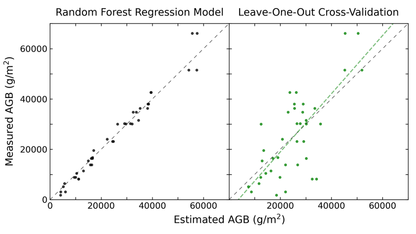
Figure 2. Performance of the forest aboveground biomass (AGB) model. Error distributions for the overall random forest model (left) and for the leave-one-out cross-validation (right), with the associated line of best fit.
Data Acquisition, Materials, and Methods
The study area includes the Atchafalaya and Terrebonne Basins in southern Louisiana, USA, within the Mississippi River Delta (MRD) floodplain. During Spring and Fall 2021, NASA's AVIRIS-NG and UAVSAR acquired data over regions of interest in the Atchafalaya and Terrebonne basins. Delta-X was a joint airborne and field campaign in the Mississippi River Delta. This campaign conducted both airborne (remote sensing) and field (in situ) measurements to measure hydrology, water quality, and vegetation structure. These data serve to better understand rates of soil erosion, accretion, and creation in the delta system, with the goal of building better models of how river deltas will behave under relative sea level rise. This dataset contains estimates of forest AGB derived from AVIRIS-NG surface reflectance and UAVSAR products.
AVIRIS-NG is a pushbroom spectral mapping system with a high signal-to-noise ratio (SNR) designed for high performance spectroscopy. AVIRIS-NG was developed as a successor to the Classic Airborne Visible Infrared Imaging Spectrometer (AVIRIS-C) (Green et al., 1998). The instrument covers the entire solar reflected spectrum from 380-2510 nm with a single Focal Plane Array (FPA), at a spectral sampling of approximately 5 nm. The AVIRIS- NG sensor has a 1 milliradian instantaneous field of view, providing altitude-dependent ground sampling distance ranging from sub-meter to 20 m scales. Its detector has a 640×480 pixel array, from which standard products are generated using the sensor’s 600 cross-track spatial samples and 425 spectral samples. Each acquisition is a “flight line” forming a continuous strip of pushbroom data that typically takes 1-10 minutes to acquire. Multiple aircraft overflights cover the region of interest in these strips, accumulating a combined map of the target area. For this campaign, AVIRIS-NG was implemented on a Dynamic Aviation King Air B200. The instrument has four components: 1) a sensor with its mount and camera glass mounted at a nadir port; 2) an onboard calibrator (OBC), mounted in the cabin next to the sensor; 3) a forward operator electronics rack, and 4) an aft thermal-control electronics rack.
This analysis also used L1 SLC stack products acquired during 2021-09-03 to 2021-09-13 (fall) by UAVSAR, a polarimetric L-band synthetic aperture radar flown on the NASA Gulfstream-III (C20) aircraft as part of the Delta-X campaign (Jones et al., 2022). Repeat pass interferometric synthetic aperture (InSAR) data is a standard UAVSAR product delivered by the UAVSAR processing team. These L1 data contain slant range SLC, latitude/longitude/height, look vector, doppler, and metadata files. The data are provided in SLC stack format (*.slc) with associated annotation (*.ann), latitude-longitude-height (*.llh), look vector (*.lkv), and Doppler centroid-slant range (*.dop) files. The SLC stacks are in the HH, HV, VH, and VV polarizations. The same area was sampled at approximately 30-minute intervals. The SLCs are not corrected for residual baseline (BU). A Freeman-Durden polarimetric decomposition was applied to the SLC stack products to estimate the contribution of the volume, double bounce, and surface scattering mechanisms to the overall backscatter signal.
Each AVIRIS-NG flightline was atmospherically corrected to produce Hemispherical-Directional surface reflectance datasets (Thompson et al., 2018; Thompson et al., 2019), followed by corrections BRDF-effects and sun-glint over land and water pixels, respectively (Queally et al., 2022; Greenberg et al., 2022). Then, the corrected AVIRIS-NG pixel reflectance spectra and the UAVSAR volume and double bounce scattering component values were extracted from the Pre-Delta-X and September 2021 Delta-X collections coincident with forest survey plots (Castaneda et al., 2020). This entailed 36 forest AGB survey plots from the 2015 survey and an additional three plots from 2021, with which AVIRIS-NG and UAVSAR data were paired from May 2015 (Castaneda et al., 2020) and September 2021 (Castaneda-Moya and Solohin, 2022), respectively. The final derived model was applied to forest vegetation pixels as defined by the vegetation type classification in Jensen et al. (2024).
The method outlined in Jensen et al. (2019) was amended to integrate the two remotely sensed datasets. First, a four component partial least squares (PLS) transformation of the AVIRIS-NG reflectance data was performed and the “x-score” values associated with each component were extracted. These values represent the normalized scores for the dimensionally reduced training data before each training variable is weighted with respect to the dependent variable (AGB) to calculate the component loading values. In doing so, the entire reflectance spectrum associated with each AGB sample was reduced to statistically independent variables suited for combination with other data. The x-scores were then combined with the volume and double bounce scattering values from the UAVSAR Freeman-Durden polarimetric decomposition.
These data (n=39) were used to train a random forest regression model to estimate forest AGB, where the independent variables are the four PLS component x-scores and the volume and double bounce scattering components. The models were applied to the co-registered AVIRIS-NG and UAVSAR imagery to map AGB. A low pass filter with a 5x5 window was applied to the resulting AGB maps, which were then converted to megagrams per hectare (Mg ha-1) for the final products.
The AGB regression model was largely trained with data from Salix nigra plots. Mangroves are present in Terrebonne Bay, and while they are classified as forest, the AGB model was not applicable to mangrove pixels. For each mangrove pixel, a standard canopy height of 0.65 m was assumed based on measurements from near Grand Isle (Jung et al. 2024). A resulting constant AGB value of 6.5 Mg ha-1 based on regression analysis from Simard et al. (2006) was used for these pixels.
Data Access
These data are available through the Oak Ridge National Laboratory (ORNL) Distributed Active Archive Center (DAAC).
Delta-X AVIRIS-NG and UAVSAR L3 Derived Forest Aboveground Biomass, MRD, LA
Contact for Data Center Access Information:
- E-mail: uso@daac.ornl.gov
- Telephone: +1 (865) 241-3952
References
Castaneda, E., A.I. Christensen, M. Simard, A. Bevington, R. Twilley, and A. Mccall. 2020. Pre-Delta-X: Vegetation Species, Structure, Aboveground Biomass, MRD, LA, USA, 2015. ORNL DAAC, Oak Ridge, Tennessee, USA. https://doi.org/10.3334/ORNLDAAC/1805
Castañeda-Moya, E., and E. Solohin. 2023. Delta-X: Aboveground Biomass and Necromass across Wetlands, MRD, Louisiana, 2021, V2. ORNL DAAC, Oak Ridge, Tennessee, USA. https://doi.org/10.3334/ORNLDAAC/2237
Green, R.O., M.L. Eastwood, C.M. Sarture, T.G.Chrien, M. Aronsson, B.J. Chippendale, J.A. Faust, B.E. Pavri, C.J. Chovit, M. Solis, M.R. Olah, and O.Williams. 1998. Imaging spectroscopy and the Airborne Visible/Infrared Imaging Spectrometer (AVIRIS). Remote Sensing of the Environment 65:227-248. https://doi.org/10.1016/S0034-4257(98)00064-9 https://doi.org/10.3390/rs11212533
Greenberg, E., D.R. Thompson, D. Jensen, P.A. Townsend, N. Queally, A. Chlus, C.G. Fichot, J.P. Harringmeyer, and M. Simard. 2022. An improved scheme for correcting remote spectral surface reflectance simultaneously for terrestrial BRDF and water-surface sunglint in coastal environments. Journal of Geophysical Research: Biogeosciences 127:e2021JG006712. https://doi.org/10.1029/2021JG006712
Jensen, D., K.C. Cavanaugh, M. Simard, G.S. Okin, E. Castañeda-Moya, A. McCall, and R.R. Twilley. 2019. Integrating imaging spectrometer and synthetic aperture radar data for estimating wetland vegetation aboveground biomass in coastal Louisiana. Remote Sensing 11:2533. https://doi.org/10.3390/rs11212533
Jensen, D.J., E. Castañeda-Moya, E. Solohin, A. Rovai, D.R. Thompson, and M. Simard. 2023. Delta-X: AVIRIS-NG L3 Derived Aboveground Biomass, MRD, Louisiana, USA, 2021, V2. ORNL DAAC, Oak Ridge, Tennessee, USA. https://doi.org/10.3334/ORNLDAAC/2138
Jensen, D.J., M. Simard, R. Twilley, E. Castaneda, and A. McCall. 2021. Pre-Delta-X: Aboveground Biomass and Vegetation Maps, Wax Lake Delta, LA, USA, 2016. ORNL DAAC, Oak Ridge, Tennessee, USA. https://doi.org/10.3334/ORNLDAAC/1821
Jensen, D.J., E. Castañeda-Moya, E. Solohin, D.R. Thompson, and M. Simard. 2024. Delta-X AVIRIS-NG L3 Derived Vegetation Types, MRD, Louisiana, USA. ORNL DAAC, Oak Ridge, Tennessee, USA. https://doi.org/10.3334/ORNLDAAC/2352
Jones, C., M. Simard, Y. Lou, and T. Oliver-Cabrera. 2022. Delta-X: UAVSAR L1 Single Look Complex (SLC) Stack Products, MRD, Louisiana, 2021. ORNL DAAC, Oak Ridge, Tennessee, USA. https://doi.org/10.3334/ORNLDAAC/1984
Jung, H., L. Moss, T.J. Carruthers, D.R. Di Leonardo, K. DeMarco, M. Whalen, M. Brasher, and J. Dijkstra. 2024. Modeling potential benefits of fragmented marsh terrace restoration in Terrebonne bay, Louisiana: sediment processes interacting with vegetation and potential submerged aquatic vegetation habitat.& Frontiers in Environmental Science 12:1432732. https://doi.org/10.3389/fenvs.2024.1432732
Queally, N., Z. Ye, T. Zheng, A. Chlus, F. Schneider, R.P. Pavlick, and P.A. Townsend. 2022. FlexBRDF: A flexible BRDF correction for grouped processing of airborne imaging spectroscopy flightlines. Journal of Geophysical Research: Biogeosciences 127:e2021JG006622. https://doi.org/10.1029/2021JG006622
Simard, M., K. Zhang, V.H. Rivera-Monroy, M.S. Ross, P.L. Ruiz, E. Castañeda-Moya, R.R. Twilley, and E. Rodriguez. 2006. Mapping height and biomass of mangrove forests in Everglades National Park with SRTM elevation data. Photogrammetric Engineering & Remote Sensing 72:299-311. https://doi.org/10.14358/PERS.72.3.299
Thompson, D.R., V. Natraj, R.O. Green, M.C. Helmlinger, B.C. Gao, and M.L. Eastwood. 2018. Optimal estimation for imaging spectrometer atmospheric correction. Remote sensing of environment 216:355-373. https://doi.org/10.1016/j.rse.2018.07.003
Thompson, D.R., K. Cawse-Nicholson, Z. Erickson, C. Fichot, C. Frankenberg, B.-C.Gao, M.M. Gierach, R.O. Green, D. Jensen, V. Natraj, and A. Thompson. 2019. A unified approach to estimate land and water reflectances with uncertainties for coastal imaging spectroscopy. Remote Sensing of Environment 231:111198. https://doi.org/10.1016/j.rse.2019.05.017
Thompson, D.R., D.J. Jensen, J.W. Chapman, M. Simard, and E. Greenberg. 2023. Delta-X: AVIRIS-NG L2B BRDF-Adjusted Surface Reflectance and Mosaics, MRD, 2021, V3. ORNL DAAC, Oak Ridge, Tennessee, USA. https://doi.org/10.3334/ORNLDAAC/2139