Documentation Revision Date: 2025-06-20
Dataset Version: 3
Summary
There are 10 data files with this dataset in cloud optimized GeoTIFF (.tif) format.
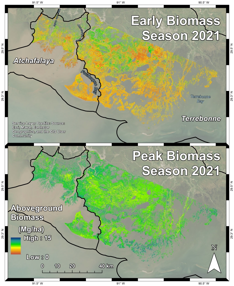
Figure 1. Herbaceous aboveground biomass (Mg/ha) product for the Atchafalaya and Terrebonne Basins derived from AVIRIS-NG data collected during the Spring and Fall 2021 campaigns.
Citation
Jensen, D.J., E. Castañeda-Moya, E. Solohin, D.R. Thompson, and M. Simard. 2025. Delta-X: AVIRIS-NG L3 Derived Herbaceous Aboveground Biomass, MRD, Louisiana, USA, V3. ORNL DAAC, Oak Ridge, Tennessee, USA. https://doi.org/10.3334/ORNLDAAC/2409
Table of Contents
- Dataset Overview
- Data Characteristics
- Application and Derivation
- Quality Assessment
- Data Acquisition, Materials, and Methods
- Data Access
- References
- Dataset Revisions
Dataset Overview
This dataset includes high-resolution (~5 m) gridded estimates of aboveground biomass (AGB), aboveground necromass (AGN), aboveground net primary productivity (ANPP) for herbaceous vegetation in the Atchafalaya and Terrebonne basins of the Mississippi River Delta in coastal Louisiana, USA, for the fall and spring seasons of 2021. AGB, AGN and ANPP were estimated from Bidirectional Reflectance Distribution Function (BRDF)-adjusted surface reflectance products (Thompson et al. 2023) from NASA's Airborne Visible Infrared Imaging Spectrometer - Next Generation (AVIRIS-NG) acquired over the study area in April and August 2021. The BRDF-adjusted reflectance was derived from hemispherical-directional surface reflectance with atmospheric correction (Thompson et al. 2018, 2019). Local pixel reflectance spectra coincident with herbaceous vegetation AGB field samples (Castañeda-Moya and Solohin, 2022) from both Spring and Fall 2021 collections were used to generate a machine learning-based regression model to estimate AGB. This model was then scaled to the AVIRIS-NG mosaic imagery in accordance with vegetation type (Jensen et al. 2024a) to map herbaceous AGB across the Atchafalaya and Terrebonne Basins. The AGN field data, separated from the AGB samples, were also used in conjunction with AVIRIS-NG-derived fractional coverage to derive AGN maps again employing machine learning. The AGB and AGN products were used together to map ANPP across the Atchafalaya and Terrebonne Basins. The data are provided in cloud optimized GeoTIFF (COG) format. This Version 3 dataset replaces the files provided in Version 2.
Delta-X was a joint airborne and field campaign in the Mississippi River Delta that took place during Spring and Fall 2021. The Delta-X campaign conducted airborne (remote sensing) and field (in situ) measurements to observe hydrology, water quality (e.g., total suspended solids (TSS)), and vegetation structure. This data serves for the continued development of algorithms and models. The Delta-X algorithms are used to convert remote sensing observables to geophysical parameters, and to develop numerical, hydrodynamic and ecological models. These data and related models serve to better understand rates of soil erosion, accretion, and creation in the delta system, with the goal of building better models of how river deltas will behave under relative sea level rise.
Project: Delta-X
The Delta-X mission is a 5-year NASA's Earth Venture Suborbital-3 mission to study the Mississippi River Delta in the United States, which is growing and sinking in different areas. River deltas and their wetlands are drowning as a result of sea level rise and reduced sediment inputs. The Delta-X mission will determine which parts will survive and continue to grow, and which parts will be lost. Delta-X begins with airborne and in situ data acquisition and carries through data analysis, model integration, and validation to predict the extent and spatial patterns of future deltaic land loss or gain.
Related Datasets
Castañeda-Moya, E., and E. Solohin. 2023. Delta-X: Aboveground Biomass and Necromass across Wetlands, MRD, Louisiana, 2021, V2. ORNL DAAC, Oak Ridge, Tennessee, USA. https://doi.org/10.3334/ORNLDAAC/2237
Jensen, D.J., M. Simard, R. Twilley, E. Castaneda, and A. McCall. 2021. Pre-Delta-X: Aboveground Biomass and Vegetation Maps, Wax Lake Delta, LA, USA, 2016. ORNL DAAC, Oak Ridge, Tennessee, USA. https://doi.org/10.3334/ORNLDAAC/1821
Jensen, D.J., E. Castañeda-Moya, E. Solohin, D.R. Thompson, and M. Simard. 2024. Delta-X AVIRIS-NG L3 Derived Vegetation Types, MRD, Louisiana, USA. ORNL DAAC, Oak Ridge, Tennessee, USA. https://doi.org/10.3334/ORNLDAAC/2352
Jensen, D.J., E. Solohin, E. Castañeda-Moya, D.R. Thompson, and M. Simard. 2025. Delta-X: AVIRIS-NG L2B Derived Fractional Cover, MRD, LA, USA, 2021. ORNL DAAC, Oak Ridge, Tennessee, USA. https://doi.org/10.3334/ORNLDAAC/2407
Thompson, D.R., D.J. Jensen, J.W. Chapman, M. Simard, and E. Greenberg. 2023. Delta-X: AVIRIS-NG L2B BRDF-Adjusted Surface Reflectance and Mosaics, MRD, 2021, V3. ORNL DAAC, Oak Ridge, Tennessee, USA. https://doi.org/10.3334/ORNLDAAC/2139
Acknowledgments
This work was supported by NASA Earth Venture Suborbital-3 (EVS-3) program (grant NNH17ZDA001N-EVS3).
Data Characteristics
Spatial Coverage: Atchafalaya and Terrebonne Basins, southern coast of Louisiana, USA
Temporal Coverage: 2021-04-01 to 2021-08-25
Temporal Resolution: One time estimates for April and August 2021
Spatial Resolution: 4.8 m
Site Boundaries: Latitude and longitude are given in decimal degrees.
|
Site |
Westernmost Longitude |
Easternmost Longitude |
Northernmost Latitude |
Southernmost Latitude |
|---|---|---|---|---|
|
Atchafalaya and Terrebonne Basins |
-91.5934 |
-90.3607 |
29.7070 |
28.9907 |
Data File Information
There are 10 data files in cloud optimized GeoTIFF (.tif) format in this dataset. The data are aboveground biomass (agb), aboveground necromass (agn), and net primary productivity (anpp).
The files are named ang<YYYYMMDD>-<DD>_<var>_<basin>_herbaceous.tif, where
- <YYYYMMDD> = beginning date of AVIRIS-NG imagery acquisition
- <DD> = ending date of imagery acquisition in the same month but note that "0822" is August 22, 2021.
- <var> = data product: aboveground biomass (agb), aboveground necromass (agn), and net primary productivity (anpp)
- <basin> = Atchafalaya (Atcha) or Terrebonne (Terre) basin
Example file names: ang20210401-05_agb_v3_Atcha_herbaceous.tif, ang20210401-0822_anpp_Atcha_herbaceous.tif, ang20210820-25_agn_Atcha_herbaceous.tif
GeoTIFF characteristics:
- coordinate system: UTM projection, zone 15N, WGS 84 datum; EPSG 32615
- spatial resolution: 4.8 m
- pixel values: biomass in Mg ha-1
- no data value: -9999
- number of bands: 1
Application and Derivation
Aboveground biomass (AGB), necromass (AGN), and net primary productivity (ANPP) are key indicators of vegetation composition, productivity, and carbon content. The data estimated here can inform maps of ecogeomorphic zones and models of accretionary processes such as sediment trapping and organic matter deposition. AGB estimates can also be used to assess wetland carbon stocks, or “blue carbon,” and ANPP estimates show seasonal growth patterns across the landscape.
Quality Assessment
Aboveground biomass (AGB), aboveground necromass (AGN), and annual net primary production (ANPP) for herbaceous vegetation were estimated using random forests regression models. Uncertainty assessments were included in the model buiding procedure and are detailed in Section 5 below.
The herbaceous wetland AGB model attained a model R2 of 0.890 and a mean absolute error (MAE) of 109.304 g m-2. For reference, the mean sample AGB value is 613.639 g m-2. A leave-one-out cross-validation of the AGB model was performed across the 84 paired AGB and reflectance samples, which attained a validation R2 of 0.427 and MAE of 257.295 g m-2. The AGN maps were validated by comparing the predicted AGN values to the field sample AGN values attaining an R2 of 0.817 and an MAE of 78.333 g m-2.
Data Acquisition, Materials, and Methods
Field samples collected by Castañeda-Moya and Solohin (2022) were separated into live aboveground biomass (AGB) and necromass (AGN). Live AGB was used to calibrate the random forests regression model (Figure 2) and map AGB across the Atchafalaya and Terrebonne Basins (Figure 1), but the same approach was less effective when trained and applied on the field-derived AGN values. The resulting model saturated at a low AGN value and was unable to accurately predict higher AGN values due to chlorophyll and canopy water content’s impact on the reflectance signal (Jensen et al., 2024b).
Hyperspectral Imagery and Surface Reflection Products
AVIRIS-NG is a pushbroom spectral mapping system with a high signal-to-noise ratio (SNR) designed for high performance spectroscopy. AVIRIS-NG was developed as a successor to the Airborne Visible Infrared Imaging Spectrometer-Classic (AVIRIS-C) (Green et al., 1998). The AVIRIS-NG instrument covers the entire solar reflected spectrum from 380-2510 nm with a single Focal Plane Array (FPA), at a spectral sampling of approximately 5 nm. The sensor has a 1 milliradian instantaneous field of view, providing altitude-dependent ground sampling distance ranging from sub-meter to 20 m scales. Its detector has a 640×480 pixel array, from which standard products are generated using the sensor’s 600 cross-track spatial samples and 425 spectral samples. Each acquisition is a “flight line” forming a continuous strip of pushbroom data that typically takes 1-10 minutes to acquire. Multiple aircraft overflights cover the region of interest in these strips, accumulating a combined map of the target area. For this campaign, AVIRIS-NG was implemented on a Dynamic Aviation King Air B200. The instrument has four components: 1) a sensor with its mount and camera glass mounted at a nadir port; 2) an onboard calibrator (OBC), mounted in the cabin next to the sensor; 3) a forward operator electronics rack; and 4) an aft thermal-control electronics rack.
Each AVIRIS-NG flightline was atmospherically corrected to produce Hemispherical-Directional surface reflectance datasets (Thompson et al., 2018, 2019), followed by corrections for BRDF-effects and sun-glint over land and water pixels, respectively (Queally et al., 2022, Greenberg et al., 2022). The corrected pixel reflectance spectra coincident with herbaceous vegetation field samples (Castañeda-Moya and Solohin, 2022) from both Spring and Fall 2021 collections were used to generate a machine learning model to estimate AGB. All models herein are applied to herbaceous vegetation pixels as defined by the vegetation type classification in Jensen et al. (2024a). The AGN field data, separated from the AGB samples, were also used in conjunction with AVIRIS-NG-derived fractional coverage data (Jensen et al., 2025) to derive AGN maps again employing machine learning. The AGB and AGN products were used together to map ANPP across the Atchafalaya and Terrebonne Basins.
Aboveground Biomass
The herbaceous aboveground biomass (AGB) sample data (g m-2) were paired with coincident AVIRIS-NG pixel reflectance spectra and fed into a random forests regression model to estimate AGB. The model utilized the visible-shortwave infrared reflectances as the independent variables to estimate AGB. Additional corrections were applied to the input spectra and mosaic imagery collected in August across the 880-1000 and 1080-1200 nm bands. These corrections interpolated the reflectances where there was excess noise from water vapor absorption using a conditional Gaussian interpolation algorithm trained on the EMIT vegetation spectral library. To apply the AGB model to the AVIRIS-NG data, the Spring and Fall mosaics were classified for both the Atchafalaya and Terrebonne Basins to separate herbaceous vegetation from forest, floating aquatic vegetation, soil, and water. For the August data, clouded and shadowed areas were filled with AGB estimates from a follow-on AVIRIS-NG survey conducted from 23-25 September 2021, using the same random forests model. Then, the regression model was applied to the image mosaics for the classified herbaceous wetland pixels. The final products were converted to megagrams per hectare (Mg ha-1).
Uncertainty in the model was characterized by compiling model performance statistics and applying a leave-one-out cross validation. The herbaceous wetland AGB model attained a model R2 of 0.890 and a mean absolute error (MAE) of 109.304 g m-2. For reference, the mean sample AGB value is 613.639 g m-2. A leave-one-out cross-validation of the model was performed across the 84 paired AGB and reflectance samples, which attained a validation R2 of 0.427 and MAE of 257.295 g m-2.
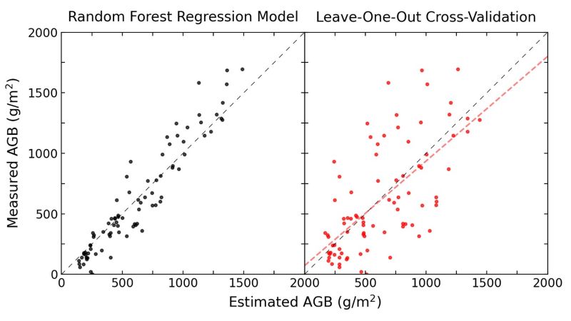
Figure 2. Aboveground biomass (AGB) estimate error distributions for the overall random forests model (left) and for the leave-one-out cross-validation (right), with the associated line of best fit.
Aboveground Necromass
Field samples collected by Castañeda-Moya and Solohin (2022) were separated into live aboveground biomass (AGB) and necromass (AGN). Live AGB was used to calibrate the random forests regression model (Figure 2) and map AGB across the Atchafalaya and Terrebonne Basins (Figure 1), but the same approach was ineffective when trained and applied on the field-derived AGN values. This was live biomass creates the dominant reflectance signal in the marsh vegetation, largely through chlorophyll and canopy water content (Jensen et al., 2024b). The resulting model trained on the sample reflectances saturates at a low AGN value and was unable to accurately predict higher AGN values.
Fractional cover estimates of green vegetation (GV), non-photosynthetic vegetation (NPV), and soil (Jensen et al., 2025) were used to augment the modelling approach and accurately estimate AGN and ANPP. Since the fractional cover estimates of GV and NPV approximate the field sample AGB and AGN concentrations, respectively, the ratio of AGN to total plant material was modeled as:
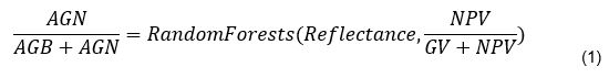
This random forests model attained an R2 of 0.962 and an MAE of 3.28%. Equation 1’s model predicts the biomass ratio [i.e., AGN / (AGB+AGN) ] that is carried forward into Equation 2 below as the BiomassRatio term. Then, AGN was predicted using the biomass ratio and the AGB product (Figure 1):
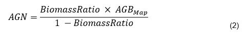
This calculation produced the AGN maps (e.g., Figure 3). These maps were validated by comparing the predicted AGN values to the field sample AGN values attaining an R2 of 0.817 and an MAE of 78.333 g m-2 (Figure 4).
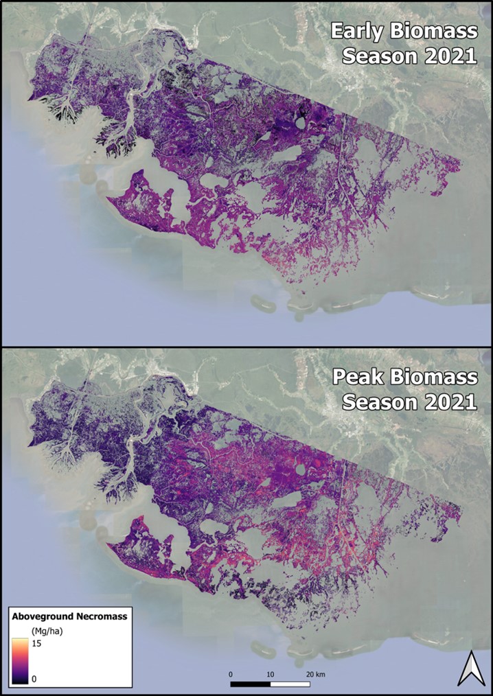
Figure 3. Herbaceous aboveground necromass (Mg ha-1) products for the Atchafalaya and Terrebonne Basins derived from AVIRIS-NG data collected during the Spring and Fall 2021 campaigns.
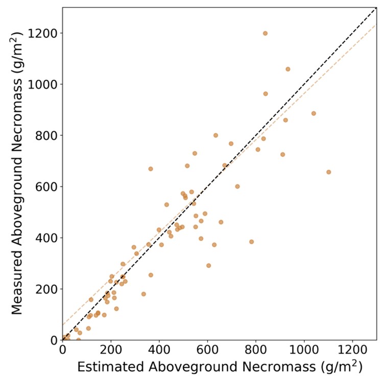
Figure 4. Error distributions for the aboveground necromass products derived from Equations 1 and 2 (R2 = 0.817, MAE = 78.333 g m-2).
Aboveground Net Primary Productivity
Aboveground net primary productivity (ANPP) for these herbaceous wetland was calculated using estimates of AGB and AGN for herbaceous vegetation across the Atchafalaya and Terrebonne Basins during both the early and peak growing seasons. To do so, the Smalley Method for marsh productivity estimates (Smalley, 1959) was adapted, whereby:
- If changes in both live and dead biomass are positive for a sampling interval, production equals the sum of those changes.
- If changes in both live and dead biomass are negative, then production is zero.
- If the standing live biomass decreased through the interval and dead biomass increased, and if their algebraic sum is positive, then production equals that value. If the algebraic sum is negative, production is zero.
- If live biomass increased and dead biomass decreased through the interval, production equals the live biomass value. (Shew et al., 1981)
These rules were interpreted as logical operators for our Spring and Fall 2021 AGB and AGN products. The differentiation between AGB and AGN in this method necessitated the development of a tailored methodology to accurately estimate these two vegetation components independently, rather than aggregating all plant mass into a single measurement. Herbaceous ANPP (Figure 5) for both the Atchafalaya and Terrebonne Basins was produced following this approach. This map provides a detailed spatial representation of herbaceous vegetation productivity across the Atchafalaya and Terrebonne Basins during the 2021 growing season.
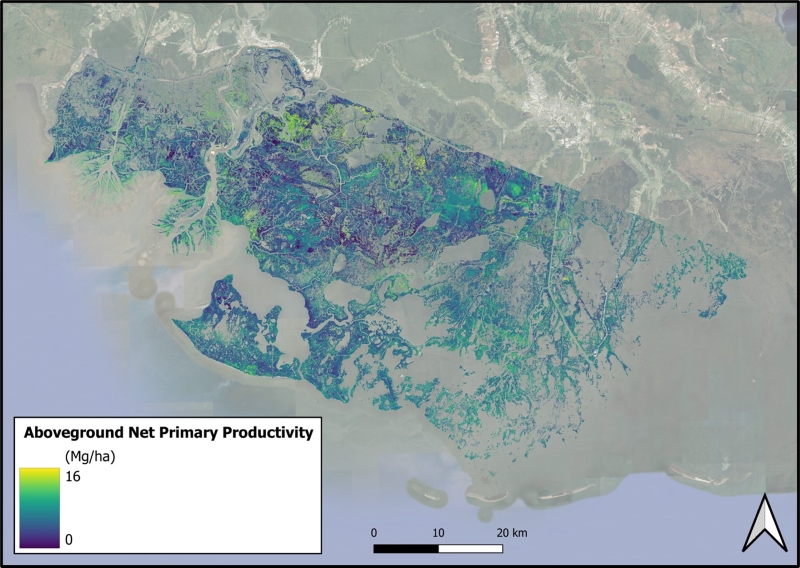
Figure 5. Herbaceous aboveground net primary productivity (Mg/ha) product for the 2021 growing season across the Atchafalaya and Terrebonne Basins.
Data Access
These data are available through the Oak Ridge National Laboratory (ORNL) Distributed Active Archive Center (DAAC).
Delta-X: AVIRIS-NG L3 Derived Herbaceous Aboveground Biomass, MRD, Louisiana, USA, V3
Contact for Data Center Access Information:
- E-mail: uso@daac.ornl.gov
- Telephone: +1 (865) 241-3952
References
Castañeda-Moya, E., and E. Solohin. 2023. Delta-X: Aboveground Biomass and Necromass across Wetlands, MRD, Louisiana, 2021, V2. ORNL DAAC, Oak Ridge, Tennessee, USA. https://doi.org/10.3334/ORNLDAAC/2237
Green, R.O., M.L. Eastwood, C.M. Sarture, T.G. Chrien, M. Aronsson, B.J. Chippendale, J.A. Faust, B.E. Pavri, C.J. Chovit, M. Solis, M.R. Olah, and O. Williams. 1998. Imaging Spectroscopy and the Airborne Visible/Infrared Imaging Spectrometer (AVIRIS). Remote Sensing of Environment 65:227–248. https://doi.org/10.1016/S0034-4257(98)00064-9
Greenberg, E., D.R. Thompson, D. Jensen, P.A. Townsend, N. Queally, A. Chlus, C.G. Fichot, J.P. Harringmeyer, and M. Simard. 2022. An improved scheme for correcting remote spectral surface reflectance simultaneously for terrestrial BRDF and water-surface sunglint in coastal environments. Journal of Geophysical Research: Biogeosciences 127:e2021JG006712. https://doi.org/10.1029/2021JG006712
Jensen, D.J., E. Castañeda-Moya, E. Solohin, D.R. Thompson, and M. Simard. 2024a. Delta-X AVIRIS-NG L3 Derived Vegetation Types, MRD, Louisiana, USA. ORNL DAAC, Oak Ridge, Tennessee, USA. https://doi.org/10.3334/ORNLDAAC/2352
Jensen, D.J., E. Solohin, E. Castañeda-Moya, D.R. Thompson, and M. Simard. 2025. Delta-X: AVIRIS-NG L2B Derived Fractional Cover, MRD, LA, USA, 2021. ORNL DAAC, Oak Ridge, Tennessee, USA. https://doi.org/10.3334/ORNLDAAC/2407
Jensen, D.J., M. Simard, R. Twilley, E. Castaneda, and A. McCall. 2021. Pre-Delta-X: Aboveground Biomass and Vegetation Maps, Wax Lake Delta, LA, USA, 2016. ORNL DAAC, Oak Ridge, Tennessee, USA. https://doi.org/10.3334/ORNLDAAC/1821
Jensen, D., D.R. Thompson, M. Simard, E. Solohin, and E. Castañeda-Moya. 2024b. Imaging spectroscopy-based estimation of aboveground biomass in Louisiana’s coastal wetlands: toward consistent spectroscopic retrievals across atmospheric states. Journal of Geophysical Research: Biogeosciences 129:e2024JG008112. https://doi.org/10.1029/2024JG008112
Queally, N., Z. Ye, T. Zheng, A. Chlus, F. Schneider, R.P. Pavlick, and P.A. Townsend. 2022. FlexBRDF: A flexible BRDF correction for grouped processing of airborne imaging spectroscopy flightlines. Journal of Geophysical Research: Biogeosciences 127:e2021JG006622. https://doi.org/10.1029/2021JG006622
Shew, D.M., R.A. Linthurst, and E.D. Seneca. 1981. Comparison of production computation methods in a southeastern North Carolina Spartina alterniflora salt marsh. Estuaries 4:97-109. https://doi.org/10.2307/1351672
Smalley, A.E. 1959. The role of two invertebrate populations, Littorina irrorata and Orchelimum fidicinium in the energy flow of a salt marsh ecosystem. Ph.D. Thesis. University of Georgia; Athens, Georgia. 126 p.
Thompson, D.R., D.J. Jensen, J.W. Chapman, M. Simard, and E. Greenberg. 2023. Delta-X: AVIRIS-NG L2B BRDF-Adjusted Surface Reflectance and Mosaics, MRD, 2021, V3. ORNL DAAC, Oak Ridge, Tennessee, USA. https://doi.org/10.3334/ORNLDAAC/2139
Thompson, D.R., V. Natraj, R.O. Green, M.C. Helmlinger, B.-C. Gao, and M.L. Eastwood. 2018. Optimal estimation for imaging spectrometer atmospheric correction. Remote Sensing of Environment 216:355–373. https://doi.org/10.1016/j.rse.2018.07.003
Thompson, D.R., K. Cawse-Nicholson, Z. Erickson, C.G. Fichot, C. Frankenberg, B.-C. Gao, M.M. Gierach, R.O. Green, D. Jensen, V. Natraj, and A. Thompson. 2019. A unified approach to estimate land and water reflectances with uncertainties for coastal imaging spectroscopy. Remote Sensing of Environment 231:111198. https://doi.org/10.1016/j.rse.2019.05.017
Dataset Revisions
| Version | Release Date | Revision Notes |
|---|---|---|
| 3.0 | 2025-06-20 | New data files for aboveground necromass (agn) and net primary productivity (anpp) were added, and the files for aboveground biomass were regenerated using an updated algorithm. |
| 2.0 | 2023-03-15 | All four data files replaced for Version 2 (https://doi.org/10.3334/ORNLDAAC/2138). |
| 1.0 | 2022-11-11 | Original Version 1 release (https://doi.org/10.3334/ORNLDAAC/2107). |