Documentation Revision Date: 2026-05-29
Dataset Version: 1
Summary
The soil moisture and temperature files are provided in one NetCDF file, and the vegetation data are provided in one text file.
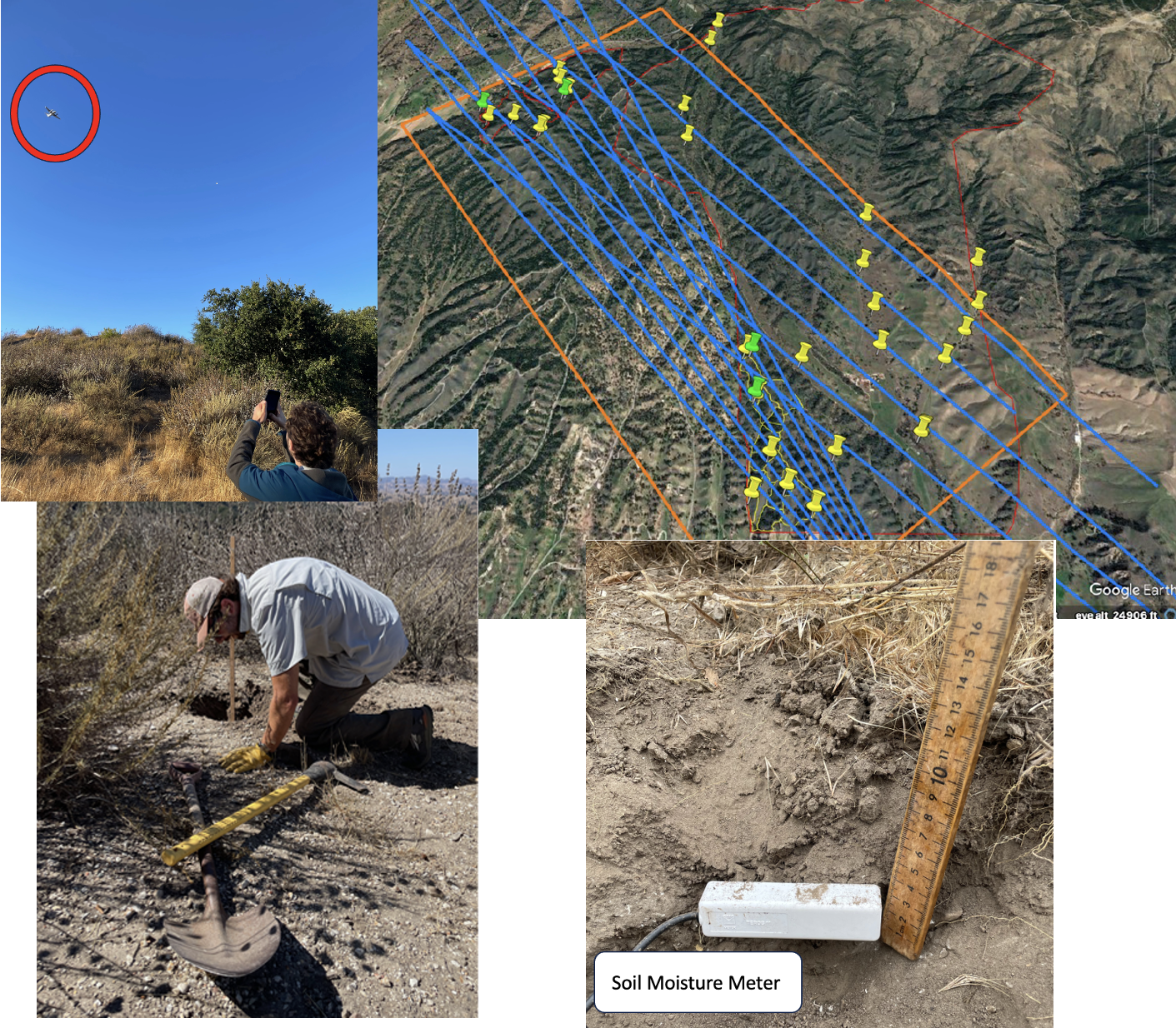
Figure 1. Pre-fire field work for the collection of soil moisture and temperature measurements for the calibration and validation of NASA's Scanning L-band Active Passive (SLAP) and Uninhabited Aerial Vehicle Synthetic Aperture Radar (UAVSAR) instruments. Measurements were made at 20, 12, 6, and 0 cm depths at 134 sites over four days.
Citation
Sousa, D.M., and E. Scrivner. 2026. FireSense: Soil and Live Fuel Moisture Content, Sedgwick Reserve, CA, USA, 2023. ORNL DAAC, Oak Ridge, Tennessee, USA. https://doi.org/10.3334/ORNLDAAC/2504
Table of Contents
- Dataset Overview
- Data Characteristics
- Application and Derivation
- Quality Assessment
- Data Acquisition, Materials, and Methods
- Data Access
- References
Dataset Overview
This dataset provides pre-fire soil moisture and soil temperature profiles, and Live Fuel Moisture Content (LFMC) of six vegetation species collected at Sedgwick Reserve in Santa Barbara County, California, between July 20 and October 2, 2023. Soil moisture and soil temperature were measured using a METER TEROS 11 probe at standardized depths within soil pits dug near the time-of-flight overpass. LFMC for six plant species were collected via repeat visits to the same locations.
Plant species include QUDO = Quercus douglasii (Blue Oak), QUAG = Quercus agrifolia (Coast Live Oak), SALE = Salvia leucophylla (Purple Sage), ARCA = Artemisia californica (California Sagebrush), PISA = Pinus sabiniana (California gray pine), and BUCK = Eriogonum fasciculatum (California Buckwheat). LFMC is computed as: ((wet weight - dry weight) / dry weight)*100. These measurements capture pre-fire baseline conditions and serve as a robust ground truth for calibrating airborne remote sensing instruments such as NASA's Scanning L-band Active Passive (SLAP) and Uninhabited Aerial Vehicle Synthetic Aperture Radar (UAVSAR).
Project: FireSense
The FireSense project is focused on measurable improvement in U.S. wildland fire management. This is accomplished by working with operational agencies responsible for wildland fire management to mature and deliver NASA’s unique Earth science and technological capabilities. FireSense focuses on four use-cases to support decisions across the fire lifecycle before, during, and after wildland fires. These include the measurement of pre-fire fuels conditions, active fire dynamics, post fire impacts and threats, as well as air quality forecasting, each co-developed with identified wildland fire management agency stakeholders. Beyond the fire lifecycle, FireSense is intended to enable a transition from reactive to proactive fire response by facilitating increased preparedness and co-existence with fire through co-development of technology and data-informed tools with communities representing resource managers, policy-makers, and stakeholders at all levels. Starting in the fall of 2023, FireSense has an annual airborne and field component where the project tests and develops improved capabilities and technologies for transfer to stakeholders. FireSense leverages multiple airborne instruments, including MODIS/ASTER Airborne Simulator (MASTER), Uninhabited Aerial Vehicle Synthetic Aperture Radar (UAVSAR), Airborne Visible/Infrared Imaging Spectrometer 3 (AVIRIS-3), Scanning L-band Active Passive (SLAP), and San Jose State University Wildfire Imaging System (SWIS).
Acknowledgements
This work was supported by the NASA FireSense Project. B. Markman and E. Scrivner served as excellent field assistants for this data collection effort. We are also grateful to the La Kretz Research Center director and staff, particularly K. Zumdahl, for further outstanding field assistance and hospitality.
Data Characteristics
Spatial Coverage: Sedgwick Reserve, Santa Barbara County, CA
Spatial Resolution: Point measurements were made at soil depths of 20, 12, 6, and 0 cm
Temporal Coverage:
Vegetation collections: 2023-07-20 to 2023-10-02
Soil moisture and temp measurements: 2023-09-25 to 2023-10-02
Temporal Resolution:
Vegetation collections: a few times between July 20 and October 2, 2023
Soil moisture and temp measurements: every 15 minutes on each data collection day
Study Area: Latitude and longitude are given in decimal degrees.
| Region | Westernmost Longitude | Easternmost Longitude | Northernmost Latitude | Southernmost Latitude |
|---|---|---|---|---|
| Sedgwick Reserve, Santa Barbara County, California | -120.627 | -120.025 | 34.743 | 34.680 |
Data File Information
There are two data files in this dataset:one file in NetCDF (.nc) format and one file in text (.txt) format.
FireSense-SoilMoisturePrfl_Ground-Other_20230925_R0_thru20231002.nc
This file provides pre-fire soil moisture and temperature profiles collected at Sedgwick Reserve in Santa Barbara County, California, between September 25 and October 2, 2023. "R0" is the revision number.
FireSense-live-fuel-moisture_Ground-Other_20230720_R0_thru20231002.txt:
This file contains data for six plant species collected via repeat visits between July 20 and October 2, 2023, to the same locations indicated in the NetCDF. The species include QUDO = Quercus douglasii (Blue Oak), QUAG = Quercus agrifolia (Coast Live Oak), SALE = Salvia leucophylla (Purple Sage), ARCA = Artemisia californica (California Sagebrush), PISA = Pinus sabiniana (California gray pine), and BUCK = Eriogonum fasciculatum (California Buckwheat). Data are reported in ((wet weight - dry_weight) / dry weight). Multiply with 100, i.e., ((wet weight - dry weight) / dry weight)*100, to get Live Fuel Moisture Content (LFMC) percent values.
Table 1. Variables in the file FireSense-SoilMoisturePrfl_Ground-Other_20230925_R0_thru20231002.nc
| Variable | Units/Formats | Description |
|---|---|---|
| Site | text | Abbreviated site names: MD = Midland Ranch, TREX = Training Exchange burn site at Sedgwick Reserve, UPPER = Upper portion of Sedgwick Reserve |
| Local Time | HH:MM | Sampling time (hour and minute) in Pacific Daylight time |
| UTCTime | HH:MM | Sampling time (hour and minute) in UTC |
| Stop Number | 1 | Sequential measurement number during AM or PM transit |
| Lon | degrees_east | Longitude of sample point (decimal degrees, WGS-84) |
| Lat | degrees_north | Latitude of sample point (decimal degrees, WGS-84) |
| Notes | text | Comments about measurements |
| SoilMoisture | m3 m-3 | Volumetric water content of soil |
| TempSoil | degrees C | Temperature of soil |
Table 2. Variables in the file FireSense-live-fuel-moisture_Ground-Other_20230720_R0_thru20231002.txt
| Variable | Units/format | Description |
|---|---|---|
| Date | YYYYMMDD | Sampling date |
| Start_Time | HH:MM | Start time (hour and minute) in UTC |
| Stop_Time | HH:MM | Stop time (hour and minute) in UTC |
| Persons | text | FIeld person |
| Site Name | text | Site name |
| Species | text | Vegetation species |
| Number_of_Samples | 1 | Number of samples |
| Bottle_Weight | g | Bottle weight |
| Bottle_Sample_Wet_Weight | g | Bottle and sample wet weight |
| Bottle_Sample_Dry_Weight | g | Bottle and sample dry weight |
| Wet_Weight | g | Sample wet weight |
| Dry_Weight | g | Sample dry weight |
| Live_Fuel_Moisture_Content | percent | Data are reported in ((wet weight - dry_weight) / dry weight). Multiply with 100, i.e., ((wet weight - dry weight) / dry weight)*100, to get Live Fuel Moisture Content (LFMC) percent values |
| Notes | text | Notes |
Application and Derivation
These measurements capture pre-fire baseline conditions and serve as a robust ground truth for calibrating airborne remote sensing instruments such as NASA's Scanning L-band Active Passive (SLAP) and Uninhabited Aerial Vehicle Synthetic Aperture Radar (UAVSAR). Soil moisture and temperature profiles are useful for fire fuel models and are critical for calibrating and ground-truthing models based on microwave remote sensing observations.
Quality Assessment
Manufacturer-stated accuracy of the soil moisture measurement is +/- 0.03 m3 m-3, with a precision of 0.0010 m3 m-3. Manufacturer-stated accuracy of the temperature measurement is +/- 0.5 degrees C, with precision of 0.1 degree.
Data Acquisition, Materials, and Methods
Pre-fire soil moisture and soil temperature profiles, and Live Fuel Moisture Content (LFMC) of six vegetation species were collected at Sedgwick Reserve in Santa Barbara County, California. Soil moisture and soil temperature were measured using a METER TEROS 11 probe at depths of 20 cm, 12 cm, 6 cm and 0 cm, between 2023-09-25 and 2023-10-02 within soil pits dug near the time-of-flight overpass (Fig. 1).
LFMC for six plant species were collected via repeat visits to the same locations. After clipping, vegetation samples were placed in Ziploc bags and stored on ice during transport back to the field station. Wet weights were generally collected within 2-4 hours of sample collection. After wet weight collection, samples were placed into paper bags, dried overnight at 80 degrees C, and weighed the following day. Live fuel moisture calculations were performed in the lab upon measurement of the dry weight.
Plant species include QUDO = Quercus douglasii (Blue Oak), QUAG = Quercus agrifolia (Coast Live Oak), SALE = Salvia leucophylla (Purple Sage), ARCA = Artemisia californica (California Sagebrush), PISA = Pinus sabiniana (California gray pine), and BUCK = Eriogonum fasciculatum (California Buckwheat).
LFMC was computed as: ((wet weight - dry weight) / dry weight)*100. These measurements capture pre-fire baseline conditions and serve as a robust ground truth for calibrating airborne remote sensing instruments such as NASA's Scanning L-band Active Passive (SLAP) and Uninhabited Aerial Vehicle Synthetic Aperture Radar (UAVSAR).
Data Access
These data are available through the Oak Ridge National Laboratory (ORNL) Distributed Active Archive Center (DAAC).
FireSense: Soil and Live Fuel Moisture Content, Sedgwick Reserve, CA, USA, 2023
Contact for Data Center Access Information:
- E-mail: uso@daac.ornl.gov
- Telephone: +1 (865) 241-3952
References
None cited.