Documentation Revision Date: 2026-08-12
Dataset Version: 1
Summary
This dataset holds 2223 NetCDF files.
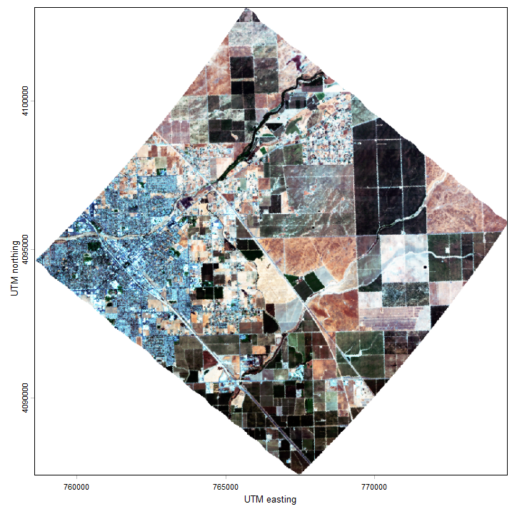
Figure 1. RGB color image of PRISM scene acquired on 2024-09-04 for the PACE-PAX campaign over Madera, California (lon -120.006, lat 36.966). Displayed coordinates are for UTM zone 10N (EPSG 32610). Bands: R 679.24 nm, G 534.64 nm, B 472.31 nm. Source: PACEPAX-PRISM-L1B_ER2_20240904190309_R0_016.nc.
Citation
Bender, H., E.D. Brunner, J.W. Chapman, R.W. Coleman, M. Eastwood, R. Eckert, M.M. Gierach, K.M.A. Luis, L.M. Rios, Z. Small, and D.R. Thompson. 2026. PRISM: L1B Calibrated Radiance for PACE-PAX, 2024. ORNL DAAC, Oak Ridge, Tennessee, USA. https://doi.org/10.3334/ORNLDAAC/2515
Table of Contents
- Dataset Overview
- Data Characteristics
- Application and Derivation
- Quality Assessment
- Data Acquisition, Materials, and Methods
- Data Access
- References
Dataset Overview
This dataset holds Level 1B (L1B) calibrated radiance data collected by the Portable Remote Imaging SpectroMeter (PRISM) instrument deployed on a NASA ER-2 aircraft over the southwestern US and eastern Pacific Ocean. The data were acquired in September 2024 for the Plankton, Aerosol, Cloud, ocean Ecosystem Postlaunch Airborne eXperiment (PACE-PAX), a field campaign to gather data to support the PACE orbital mission validation. PRISM is a compact image spectrometer that acquires data in the near ultraviolet (UV) to near infrared (IR) spectral bands between 350 and 1050 nanometers with 3.5-nm spectral resolution. PRISM's capabilities make it well suited for studies of aquatic and coastal ecosystems. This dataset includes calibrated radiance and georeferencing information.
Project: PACE-PAX
The Plankton, Aerosol, Cloud, ocean Ecosystem Postlaunch Airborne eXperiment (PACE-PAX) is a field campaign that gathered data for the validation of the PACE mission. PACE-PAX was conducted in September 2024, roughly nine months after the launch of PACE. The operational area was Southern and Central California and nearby coastal regions. Eighty-one flight hours were conducted by the NASA ER-2 and sixty flight hours were conducted by the CIRPAS Twin Otter. Both were based in their home airports at NASA Armstrong Flight Research Center and Marina Municipal Airport, respectively. Flights were coordinated between the aircraft, with PACE overflights, and with surface-based observations including ship-based measurements and floats.
Related Publication:
Knobelspiesse, K., B. Cairns, I. Cetinic, S. LeBlanc, and the PACE-PAX team. 2025. The PACE Postlaunch Airborne eXperiment (PACE-PAX): post campaign report. PACE Technical Report Series, Volume 16. NASA TM 20250011273. National Aeronautics and Space Administration, Goddard Space Flight Center; Greenbelt, Maryland. https://pace.oceansciences.org/docs/Vol16_PACETM_PACE-PAX_postcampaign-2-compressed.pdf
Knobelspiesse, K.D., J. Alfter, B. Cairns, I. Cetinic, S. LeBlanc, S. Nicholas, and R. Ueyama. 2026. Field campaign design and implementation with traceability matrix decision support. Journal of Atmospheric and Oceanic Technology 43:133–148. https://doi.org/10.1175/JTECH-D-25-0079.1
Related Datasets:
Additional data for the PACE-PAX project are available on its Earthdata Project Page.
Acknowledgements:
The PRISM instrument was sponsored by the NASA Earth Science Division, and is currently maintained, operated, and the data processing is conducted by the Jet Propulsion Laboratory, California Institute of Technology, in Pasadena, California. The dataset authors are affiliated with the Jet Propulsion Laboratory, California Institute of Technology where a portion of this research was carried out under a contract with the National Aeronautics and Space Administration (80NM0018D0004).The ER-2 flights were supported by NASA's Armstrong Flight Research Center.
Data Characteristics
Spatial Coverage: southwestern US and adjacent Pacific Ocean
Spatial Resolution: 10-50 m, altitude dependent
Temporal Coverage: 2024-09-04 to 2024-09-30
Temporal Resolution: Daily
Study Areas: All latitudes and longitudes given in decimal degrees.
| Site | Westernmost Longitude | Easternmost Longitude | Northernmost Latitude | Southernmost Latitude |
|---|---|---|---|---|
| southwestern US and Pacific Ocean |
-127.05 |
-112.23 | 42.30 | 32.44 |
Data File Information
This dataset holds 2223 NetCDF files holding Level 1B (L1B) calibrated radiance and georeferencing information.
The file naming convention is PACEPAX-PRISM-L1B_ER2_<datetime>_R0_<scene>.nc, where
- <datetime> is the time of image acquisition in YYYMMDDhhmmss format,
- <scene> is the three digit scene number (e.g, "000","001","002", ...),
- "ER2" refers to the airborne platform, and "R0" is the processing revision number.
Example file name: PACEPAX-PRISM-L1B_ER2_20240904190309_R0_015.nc
These files hold calibrated radiance in raw spatial format (not orthocorrected) and include the geometric lookup table (GLT), which provides a georeferenced location for each pixel in the raw image (Table 1). The GLT is an orthocorrected product with a fixed pixel size projected into a UTM coordinate system that contains the information about which original pixel occupies which output pixel in the final product. Orthocorrected pixels are referenced back to the raw image by the line and sample variables. The line and sample values are sign coded to indicate if it is a real measurement (indicated by a positive value) or a nearest-neighbor infill (indicated by negative values). The UTM zone for the GLT is specified in the transverse mercator variable in each file, and zones include 9N (EPSG 32609), 10N (EPSG 32610), 11N (EPSG 32611), and 12N (EPSG 32612). The nodata value is -9999.
Table 1. Variables in the NetCDFs.
| Variable | Units | Description |
|---|---|---|
| Variable group: root | ||
| lat | degrees north | Latitude for center of grid cell |
| lon | degrees east | Longitude for center of grid cell |
| elev | m | Surface elevation: height above mean sea level |
| Variable group: geolocation_lookup_table | ||
| transverse mercator | - | Projected coordinate system definition |
| easting | m | UTM easting coordinate for center of grid cell for orthocorrected pixel location |
| northing | m | UTM northing coordinate for center of grid cell for orthocorrected pixel location |
| sample | 1 | Pixel identifier in the across-track direction, indicating the column location of a pixel from the uncorrected sensor image within the orthocorrected grid. |
| line | 1 | Pixel identifier in the along-track (flight path) direction, indicating the row location of a pixel from the uncorrected sensor image within the orthocorrected grid. |
| Variable group: radiance | ||
| radiance | uW nm-1 cm-2 sr-1 | Calibrated radiance: surface upwelling radiance per unit wavelength in air |
| wavelength | nm | Center wavelength for radiance bands |
| fwhm | nm | Full width at half maximum for radiance band |
Application and Derivation
Plankton, Aerosol, Cloud, ocean Ecosystem Postlaunch Airborne eXperiment (PACE-PAX) was a field campaign to gather data to support the PACE orbital mission validation. A secondary objective was to help validate data from JAXA/ESA’s Earth Cloud, Aerosol, and Radiation Explorer (EarthCARE) mission.
Quality Assessment
The PRISM calibration procedure addresses electronic effects involving radiometric responses of each detector, optical effects involving the spatial and spectral view of each detector, and radiometric calibration. Instrument artifacts in the spectrometer data, such as striping, are removed statistically by minimizing a Markov Random Field model. Likewise, bad pixels are identified and corrected using statistical methods followed by laboratory and field protocols to evaluate effectiveness. Details of calibration methods are available in Chapman et al. (2019). Spectral information, including full width at half maximum, are included in files.
Data Acquisition, Materials, and Methods
PACE-PAX was conducted in September 2024 in western US and Pacific Ocean off the coast of California. Eighty-one flight hours were flown on the NASA ER-2 operating out of the NASA Armstrong Flight Research Center (Figure 2), and 60 hours were flown on the CIRPAS Twin Otter from Marina Municipal Airport. A NOAA vessel, the R/V Shearwater, operated 16 day trips out of Santa Barbara, while a privately owned sailboat, the R/V Blissfully, conducted 9 sorties out of Long Beach, CA. Numerous other entities cooperated to make coincident observations, many of which were members of the PACE Validation Science Team (PVST). Calibrated radiance from the PRISM instrument deployed on the ER-2 are included in this dataset.
PRISM is a pushbroom imaging spectrometer covering the near UV to near IR range (350-1050 nm) and a separate spot radiometer covering two short wave infrared (SWIR) bands at 1240 and 1610 nm respectively (Mouroulis et al., 2014). The spot radiometer was not used for PACE-PAX. At ER-2 flight altitudes, PRISM’s spatial sampling is typically in the 18 m range, making it well suited for studies of aquatic and coastal environments (Thompson et al., 2015). Additional details about the PRISM instrument are available at https://science.nasa.gov/mission/portable-remote-imaging-spectrometer-prism/.
The NetCDF files hold Level 1B calibrated at-sensor radiance measurements in uW nm-1 cm-2 sr-1. The files also contain a geometric lookup table (GLT), a dataset that links relative row and column reference locations (via line and sample variables) with the orthocorrected latitude, longitude and elevation for each pixel. Pixel locations are also provided in projected UTM coordinates. Nodata values are set to -9999.
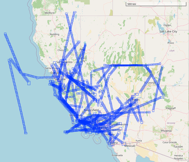
Figure 2. Map of flight scenes acquired by the PRISM instrument for the PACE-PAX campaign in 2024 over the southwestern US and eastern Pacific Ocean. Basemap: ©OpenStreetMap contributors.
Data Access
These data are available through the Oak Ridge National Laboratory (ORNL) Distributed Active Archive Center (DAAC).
PRISM: L1B Calibrated Radiance for PACE-PAX, 2024
Contact for Data Center Access Information:
- E-mail: uso@daac.ornl.gov
- Telephone: +1 (865) 241-3952
References
Chapman, J.W., D.R. Thompson, M.C. Helmlinger, B.D. Bue, R.O. Green, M.L. Eastwood, S. Geier, W. Olson-Duvall, and S.R. Lundeen. 2019. Spectral and radiometric calibration of the Next Generation Airborne Visible Infrared Spectrometer (AVIRIS-NG). Remote Sensing 11:2129. https://doi.org/10.3390/rs11182129
Knobelspiesse, K.D., J. Alfter, B. Cairns, I. Cetinic, S. LeBlanc, S. Nicholas, and R. Ueyama. 2026. Field campaign design and implementation with traceability matrix decision support. Journal of Atmospheric and Oceanic Technology 43:133–148. https://doi.org/10.1175/JTECH-D-25-0079.1
Knobelspiesse, K., B. Cairns, I. Cetinic, S. LeBlanc, and the PACE-PAX team. 2025. The PACE Postlaunch Airborne eXperiment (PACE-PAX): post campaign report. PACE Technical Report Series, Volume 16. NASA TM 20250011273. National Aeronautics and Space Administration, Goddard Space Flight Center; Greenbelt, Maryland. https://pace.oceansciences.org/docs/Vol16_PACETM_PACE-PAX_postcampaign-2-compressed.pdf
Mouroulis, P., B. Van Gorp, R.O. Green, H. Dierssen, D.W. Wilson, M. Eastwood, J. Boardman, B.-C. Gao, D. Cohen, B. Franklin, F. Loya, S. Lundeen, A. Mazer, I. McCubbin, D. Randall, B. Richardson, J.I. Rodriguez, C. Sarture, E. Urquiza, R. Vargas, V. White, and K. Yee. 2014. Portable Remote Imaging Spectrometer coastal ocean sensor: design, characteristics, and first flight results. Applied Optics 53:1363. https://doi.org/10.1364/AO.53.001363
Thompson, D.R., F.C. Seidel, B.C. Gao, M.M. Gierach, R.O. Green, R.M. Kudela, and P. Mouroulis. 2015. Optimizing irradiance estimates for coastal and inland water imaging spectroscopy. Geophysical Research Letters 42:4116–4123. https://doi.org/10.1002/2015GL063287